Valdez to Wrangell St. Elias NP Hints and Tips:Valdez is one of those ports that may leave you scratching your head as to "why are we stopping here"? The usual dockside town is absent, and in fact there doesn't seem to be much of a town. This is explained by the fact that the original town of Valdez was wiped out by the 1964 Good Friday earthquake (the 2nd largest earthquake ever reported). It was afterward determined that the town was built on unstable ground, and moved further inland. However, look beyond the port and you'll see there are lots of opportunities for thrills and true wildness experiences. In fact you'll soon discover that your stop is too short to really take advantage of what the Valdez area has to offer.
You can take the Columbia Glacier Cruise in Prince William Sound to learn about the Valdez area and enjoy what nature has to offer. If you'd rather stay on land, drive over Thompson Pass and enjoy the scenery. Take a hike to view the waterfalls. Wrangell St. Elias National Park:If you keep on driving the Richardson Highway (~ 80 miles from Valdez) you will reach the Edgerton Highway heading to the town of Chitina. Here you will find the Chitina Ranger Station, and shortly thereafter you will be able to start down one of the two roads (McCarthy) which provides access to Wrangell-St. Elias National Park. At the ranger station, you can get information about the park, permits, and road conditions.
Before reaching the end of the road at the Kennicott River, there will be an information station where you should stop to pick up "A Visitor's Guide to Kennecott and McCarthy". You may drive another mile to the end of the road and leave your car in one of the pay parking lots. You now walk across the footbridge. A pull cart is available for luggage. This is the point where shuttles will stop to take visitors to McCarthy and Kennecott. If you are staying in the town of McCarthy or Kennecott, check with your inn keeper if transport is available. Otherwise, a schedule is posted at the shuttle stop and a pay shuttle will arrive as posted. We paid the driver, but it is possible to purchase tickets before crossing the bridge. (Note the zip-line next to the footbridge. This was previously the way you and your luggage crossed the Kennicott river to reach McCarthy.) The first stop is the small but bustling town of McCarthy. The town is cute as can be, and is the place to go to arrange a variety of activities such as scenic flights, remote access flights, ice climbing, or guided tours. There is also a small historic museum situated here. You can also fly into McCarthy from Chitina if you do not wish to drive.
For many visitors, the next stop is Kennecott. Kennecott Mines is of historical significance as it once extracted the world's richest copper ore. Come get a glimpse of those times at this National Historic Landmark. Here you can walk the streets, tour and view the old buildings, hike up to the old mines, and relive the old times in your mind. In addition to hiking to the old mines, you may hike out to a glacier on the Root Glacier Trail. The trail leading to the glacier is abundant with wildflowers and spectacular scenery. You many also explore the Northern side of Wrangell-St. Elias by following the Glenn Highway to mile marker 60 (Tok cutoff) heading towards Slana. Be certain to stop at the Slana ranger station to inquire about the road condition and to pick-up "The Nabesna Road Audio Tour" cd. This is a well timed audio narration that will point out highlights as you travel down Nabesna Road. As someone who knows what motion sickness feels like, I appreciated the cd as it removed the need to follow along printed mile marker information. Much of the 42-mile long Nabesna Road is gravel and can be bumpy, so take it easy. In addition be forewarned that you will encounter several creek crossings. A high clearance four-wheel drive vehicle is recommended if you intend to explore to the end of the road. Even at that, be sure to examine each creek crossing before plowing ahead. In reward, you will be afforded beautiful but ever changing scenery and a number of lakes that may contain some interesting waterfowl. The road ends in the town of Nabesna. The right side of the road facing into Nabesna is for cars. The left side is for planes...so stay off the left! Here you will find a handful of businesses that cater to those seeking the solitude of the wilderness. Nabesna Road offers many opportunities for hiking, but be aware that this is Grizzly country. Also note that many of the trails are often pretty wet. We stopped to do a bit of hiking, but after continuously encountering large fresh Grizzly footprints heading the same direction that we were, we decided that it would be a good time to turn around. We hoped to get to the river, but apparently a Grizzly had the same idea. As usual in Alaska, be prepared for the possibility of thick mosquitoes. Once you've driven McCarthy and Nabesna Roads, you've navigated the only public roads in the park. Whatever you choose to do in Wrangell-St. Elias, it will be sure to be a peaceful and memorable wilderness experience. We can't wait to visit again!
Happy cruising and exploring! -Therese & Reid |
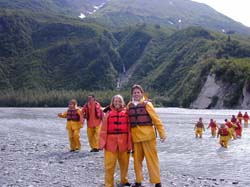 For
you thrill seekers, check out the white water rafting
opportunities in Keystone Canyon on the Lowe River. When
the water is running, your raft can just about fly! Take
the bow seat if you dare. You'll be traveling the river
with sheer cliff walls and wondrous waterfalls propelling down.
Prepare to paddle and to get a little wet despite the rain gear
that is provided. And trust me, the water is cooooold! The scenery is
wonderful, and the ride can be thrilling.
For
you thrill seekers, check out the white water rafting
opportunities in Keystone Canyon on the Lowe River. When
the water is running, your raft can just about fly! Take
the bow seat if you dare. You'll be traveling the river
with sheer cliff walls and wondrous waterfalls propelling down.
Prepare to paddle and to get a little wet despite the rain gear
that is provided. And trust me, the water is cooooold! The scenery is
wonderful, and the ride can be thrilling. McCarthy
road is a 60 mile unpaved road. Expect road travel to take
about 3 hours in each direction. No fuel or service is
available along the road, so make certain you have sufficient
fuel and a good spare tire along. The road originated as a
railroad bed, and old railroad spikes are known to have created
road hazards. The drive down the road itself is a
delightful experience. Hiking opportunities are available.
See the Park Visitors Guide which details points of interest,
hiking trailheads, and rest stops along the road.
McCarthy
road is a 60 mile unpaved road. Expect road travel to take
about 3 hours in each direction. No fuel or service is
available along the road, so make certain you have sufficient
fuel and a good spare tire along. The road originated as a
railroad bed, and old railroad spikes are known to have created
road hazards. The drive down the road itself is a
delightful experience. Hiking opportunities are available.
See the Park Visitors Guide which details points of interest,
hiking trailheads, and rest stops along the road.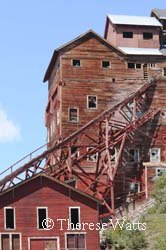 Keep
in mind that Wrangell-St. Elias is comprised of 13.2 million
acres making it the largest National Park in the nation!
This trip is just the tip of the iceberg so to speak.
Wilderness opportunities abound, and McCarthy is a great place
to plan and start your adventure.
Keep
in mind that Wrangell-St. Elias is comprised of 13.2 million
acres making it the largest National Park in the nation!
This trip is just the tip of the iceberg so to speak.
Wilderness opportunities abound, and McCarthy is a great place
to plan and start your adventure.